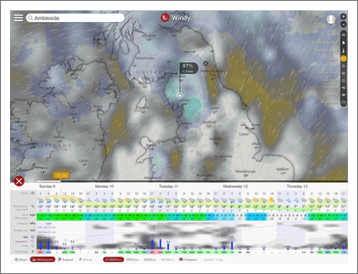
Landscape photography is about being in the right place, at the right time in the right weather conditions; so knowing what conditions are forecast is really important. I have tried lots of weather forecast apps and sites, but the one I keep using – and I find to be the most accurate – is www.windy.com
Getting in the right location and at the right time of day is easy, predicting when to be there to maximise the chance of getting the right conditions is much, much harder. This means we spend ages looking at the forecast for the week ahead to decide when to do that 2-hour drive somewhere.
I have found what I think is the best weather forecasting site (and it also has iOS and Android support) which is Windy.com. Windy allows you to see a fantastic interactive map of the forecast for the area you are interested in and allows you to toggle different weather elements on the map; for example to show the wind; clouds (including forecasts for low, medium and high clouds); rainfall, snowfall; and more.
Most weather sites use only the GFS model as it is free, whereas one of the most accurate models is ECMWF which normally would mean paying to access forecasts using this model. However; Windy.com paid for ECMWF and has made it available free of charge. Windy.com does provide access to a number of different global and local weather models and you can select which one you want to use. I always use the ECMWF model, but sometimes I will use the Compare option which lets me view the different forecast from each model in one table. It is worth noting that the ECMWF model is updated every three hours for the next 6 days and every 6 hours for days 7 to 10.
Another really nice view is the Metrogram view which provides a visual forecast at a glance for a selected location, and importantly to me, shows the forecasted cloud coverage by the height of cloud, along with the predicted rainfall (see the image at the top of this blog for an example).
The best thing to do is try it for yourself at www.windy.com – it is free.
